· Robin Wen · Industry & Manufacturing · 13 min read
Wuyang Trades the North for the Belt
Wuyang's 39-degree orbit serves the tropics and gives up the north. Planet flew the same idea and stopped. Who pays decides the rest.
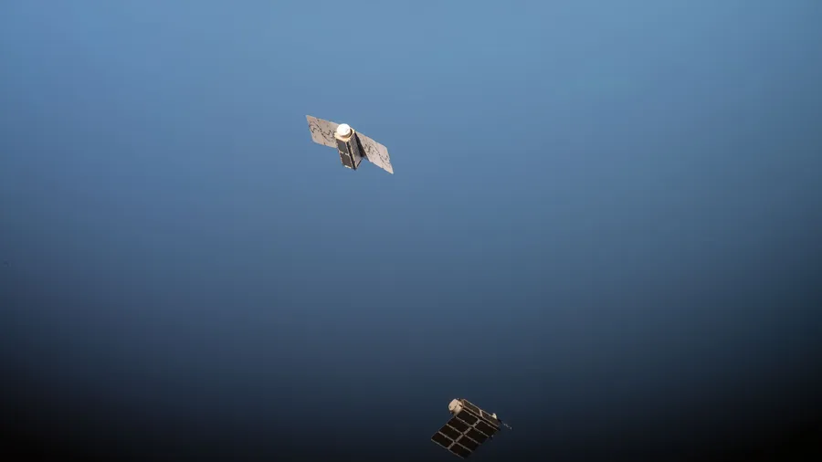
Photo: Two Doves released from the ISS, September 2016 · NASA/Kate Rubins · Public domain · Wikimedia Commons · cropped to 1.91:1
At 11:39 on 21 October a rocket lifted off from the launch ship Dongfang Aerospace Port in the Yellow Sea off Rizhao and put a 300-kilogram satellite into a 541-kilometre orbit inclined 39 degrees to the equator. The satellite answers to three names. Its manufacturer calls it Xiguang 4-01, the project calls it Wuyang Pilot A, and the university that leads the project calls it Guangda-1.
The launch was routine work for the launch company: the seventh sea launch of the Ceres-1 and the rocket’s twenty-fourth flight. The orbit is the part worth reading. The paper reports that more than 95 per cent of the world’s Earth-observation system flies sun-synchronous (Yangcheng Evening News, 21 October). Those orbits keep the light the same from one pass to the next, and they leave the low latitudes with fewer passes a day. The company that built this satellite states the geometry without decoration: a sun-synchronous constellation revisits Beijing more often than Guangzhou, and Guangzhou more often than the equator (Securities Times, 21 October).
So the case holds together. Move the supply to where the people are. The argument is also twelve years old, and it has been tried once already.
It has flown before
Planet Labs sent its first Flock of 28 Doves to the International Space Station in January 2014 and released the first pair from the station on 11 February. The orbit was 51.6 degrees, non-sun-synchronous, reaching 52 degrees of latitude either side of the equator (Remote Sensing, 2021). The comparison of that orbit against the sun-synchronous one Planet’s later satellites used is the clearest account of the trade (ESA eoPortal, Planet Flock). Sun angle varies over time in the station orbit and stays consistent in the other, though it can drift over years. The thermal environment needs special handling at high solar beta angles in the first case and varies little in the second. Satellite life is 12 to 18 months against four to five years. Coverage misses northern Canada, Russia, Antarctica and the southern tip of South America.
A 2021 review of PlanetScope’s record found no public sign of a Dove launched to the station’s orbit since mid-2016, and recorded that satellites from those flocks are either flagged nonoperational or dropped from the company’s published operational report (Remote Sensing, 2021). Neither account says why the company stopped. What they do establish is a price list: a short life, a sun angle that will not hold still, a thermal environment that needs special handling, and the high latitudes gone.
The second attempt has dealt with the short life. The satellite sits at 541 kilometres (Yicai, 21 October) instead of the 400 the station orbit flies at (Remote Sensing, 2021), which cuts drag, and it carries electric propulsion that must manage manoeuvres of about 100 kilometres in altitude (Securities Times, 21 October). That is a different class of machine from a three-unit CubeSat released from the station, which re-entered once drag took it down.
Thermal is the item the orbit makes harder. At 39 degrees the sun’s incidence angle and the Earth’s infrared and reflected heat flux swing further with season and orbital position than they do in a sun-synchronous orbit, and the builder describes thermal and structural design as a hard threshold in development; it says the launch cleared both tests (Securities Times, 21 October). Whether the design holds across a 28-satellite production run is the part one satellite cannot answer.
The sun angle is the item a data customer feels. The same 2021 review records why PlanetScope’s radiometric quality drew complaints: differences between individual sensors, and imaging under variable illumination. The first cause belongs to more than a hundred tiny cameras and would not transfer, on my reading, to a fleet of 28 larger satellites. The second belongs to the orbit and does transfer. Two images of the same field, taken on different passes at different sun angles, are not comparable until something normalises them, and normalisation was work Planet did outside the camera: pre-launch calibration, monthly lunar imaging, crossovers against Landsat-8 and RapidEye (Remote Sensing, 2021). That is a processing commitment rather than a payload specification, and it is the sort of constraint that does not appear in a specification sheet, several links downstream of the hardware. None of the launch coverage I read says how Wuyang intends to handle it.
Thirty-nine and thirty-five
Two numbers travel with this launch and they are not the same number. The inclination is 39 degrees, which the constellation operator’s chief technology officer cited when explaining why the launch left from Rizhao: the rocket can fly straight to the target inclination and spare the satellite the fuel it would otherwise burn changing planes (Yangcheng Evening News, 21 October). The band the constellation is designed to serve is narrower. The paper’s own description, and its interview with the project’s executive chief designer, put the target at the latitudes within 35 degrees north and south, the strip it calls the earth’s golden belt (Yangcheng Evening News, 21 October).
Several outlets used the inclination as the band, writing that the constellation focuses on the belt between 39 degrees north and south (Securities Times; Yicai, both 21 October). The gap is four degrees of latitude, about 440 kilometres at the equator, and it matters twice over. A ground track at 39 degrees turns at 39, which puts Beijing, at 39.9, just beyond the point where the track stops climbing. The design band stops five degrees short of that. Whatever else this constellation does, Beijing is not the customer it was planned around.
That is the trade rather than an oversight. The passes go where the sun-synchronous fleets are thinnest, and the latitudes where those fleets are strongest are given up. Both halves come from the same geometry, and the Securities Times reports the half nearest the equator. The buyers therefore have to be people whose losses and assets sit inside the band. That is a different business from selling global coverage.
Why the belt can pay
The demand is not invented. ICEYE, which operates the largest SAR fleet, flies sun-synchronous satellites and now also deploys “satellites into mid-inclination orbital planes, which increase imaging opportunities at middle latitudes”, in the words of the ESA mission reference, adding coverage “where many economic and infrastructure centers are located” (ESA eoPortal, updated July 2026). A large commercial operator reached the same conclusion as the Guangzhou project.
The difference is architectural. ICEYE adds inclined planes on top of a polar backbone; Wuyang makes the inclined plane the whole constellation. For a buyer who wants a picture of anywhere, those are not the same product. For a buyer whose losses sit between 35 degrees north and south, the second puts every pass it flies over the area that matters, and that is the entire commercial case.
That buyer exists, and ICEYE’s business shows where. Its flood extent and depth products go to insurers for claims triage and reserve setting, and it supplies the hazard data behind parametric flood cover, including a programme in Ghana supported by Allianz and Swiss Re, with the UN Development Programme and the Insurance Development Forum (ESA eoPortal). Catastrophe risk is the customer base that wants a belt watched often, and it is the customer base that pays for revisit.
There is a catch in the instrument. Cloud is the constraint in the belt, and it is why the radar operators lead with imagery through cloud, rain and darkness. The pilot satellite is optical and infrared: a 0.5-metre camera, a 2-metre multispectral imager and a 30-metre wide infrared payload (Yicai, 21 October). Infrared helps at night. It does not see through cloud. The plan puts radar on the 25 operational satellites (Yangcheng Evening News, 21 October), which is the right instrument arriving after the first one.
The arithmetic of 2029
The programme is three pilot satellites and 25 operational ones, 28 in total, with full networking targeted for 2029. Two more pilots are due after April 2027, then 10 to 12 operational satellites, at which point the operator says a basic service will exist. Its chief technology officer put the whole programme at a planned 3 billion yuan (Yangcheng Evening News, 21 October). On my arithmetic that is about 107 million yuan a satellite, against a first satellite that has just reached orbit.
“Planned” is doing work in that sentence. It is the number the operator gives for what the constellation will cost, not a record of money raised or contracts signed, and none of the launch coverage I read names a customer who has paid for the data. That is a limit of the coverage rather than a finding about the company, and it is the gap that decides the rest.
What the programme does have is a supply chain that already exists. The launch company has made 23 orbital launches for 28 customers and 90 satellites (Yicai, 21 October). The manufacturer had 13 satellites in orbit once this one arrived (Securities Times, 21 October). The designer is a university with a remote-sensing institute, the operator is a company the university incubated, and the three sponsoring bodies are a national information centre, a city government and that university (Yangcheng Evening News, 21 October). Assembling parts that already work is the achievement, the pattern this site found in an airborne wind turbine.
It is also the pattern China has used on other technical bets. The country already runs sun-synchronous optical fleets at scale, and this adds a second architecture beside the first, the same habit visible in its two fusion routes. A belt constellation can fail without taking the polar fleet with it, which is a cheap way to test a route another company abandoned.
Thirty minutes is a ground problem
The targets are specific: full coverage of the target area once a day, three to five passes a day over priority areas, and a 30-minute response in a disaster (Yangcheng Evening News, 21 October). The 30-minute figure is the one to hold still and look at, because it measures a chain rather than a spacecraft: the time from someone asking for an image to someone receiving an answer, set by the slowest of four steps, which on my reading are scheduling the pass, getting the data down, processing it, and putting it in front of a decision-maker.
The pilot carries onboard processing, encryption and a satellite-to-terminal link, and the project describes data reaching users in seconds (Yangcheng Evening News, 21 October). That is the project’s account of one satellite’s capability. A 28-satellite constellation has to schedule 28 spacecraft against competing requests, and the customer’s deadline is set by the workflow on the ground.
My reading is that the orbit is the solid part of this story and the service level is the soft part. The geometry is checkable now: 39 degrees of inclination, 541 kilometres, 28 satellites, and a documented price list from the last operator who flew the idea. The 30-minute promise is checkable later, and it depends on a ground segment that does not exist yet at that scale.
Three things would move this judgement. A signed data contract with a buyer outside the belt would break the customer-list argument outright. A published account of cross-pass radiometric normalisation would answer the one technical objection that a bigger platform does not. And the two pilot satellites due after April 2027 arriving on time would turn the 2029 date from a target into a schedule. Until then, what exists is a good orbit with one satellite in it, and a business model that has been designed more carefully than it has been sold.
Methodology
I could not open an original report for a strategic cooperation between the operator and a Chinese insurer that secondary commentary on this project refers to, so I left it out instead of describing it at second hand. Whether the 3 billion yuan covers the ground segment, and how much of it is committed rather than planned, is not stated in the interview that gives the figure.
No independent remote-sensing engineer was available to me. The technical claims here come from the manufacturer’s own account, from independent mission references, and from peer-reviewed work on the earlier constellation, and where they are being joined into one argument, I say so. The belt statistics the project uses, 99 countries and more than 60 per cent of the world’s population, are its own and I have not verified them; they describe what the project is aiming at, not what it has.
Sources
- Yangcheng Evening News, “Global first: Guangdong’s low-inclination civil remote-sensing constellation launches successfully”, 21 October 2026, republished in full by HK01 — interviews with the project’s own leadership: Tong Qingxi (chief scientist), Gu Xingfa (chief designer), Ouyang Qian (commander), Wang Jinnian (executive chief designer) and An Jun (chief technology officer, Tianyuan Technology). The 35-degree service band, the 3-plus-25 programme, the 2029 date, the 3 billion yuan planned investment, the 39-degree inclination and the Rizhao launch-site reasoning, the three-payload specification, onboard processing, the 95 per cent sun-synchronous share, and the belt statistics — hk01.com
- Securities Times, “The world’s first low-inclination remote-sensing constellation, Wuyang, puts Pilot A into orbit”, 21 October 2026 — reporting the payload builder’s account, Xiguang Aerospace: the 11:39 launch from the Rizhao offshore site, the 39-degree inclination, the statement that a sun-synchronous constellation revisits Beijing more often than Guangzhou and Guangzhou more often than the equator, the thermal and structural threshold at 39 degrees, the roughly 100-kilometre electric-propulsion manoeuvre, and 13 satellites in orbit — stcn.com
- Yicai, “Wuyang’s first satellite reaches orbit, focused on the 39-degree ‘earth golden belt’”, 21 October 2026 — business daily, relaying Xiguang and the launch provider: the 541-kilometre orbit, the 300-kilogram platform and three payloads, the seventh sea launch and twenty-fourth flight of Ceres-1, and 23 orbital launches for 28 customers and 90 satellites — yicai.com
- ESA eoPortal, “Planet — Flock Imaging Constellation” (accessed 22 October 2026) — independent mission reference with an ISS-versus-sun-synchronous comparison table: sun angle varying against consistent, thermal handling at high beta angles, 390 to 450 kilometres against about 500, inclination of 51.6 against roughly 98 degrees, orbit life of 12 to 18 months against four to five years, and the coverage gaps of the station orbit — eoportal.org
- Le Roux, J., Christopher, S. and Maskey, M., “Exploring the Use of PlanetScope Data for Particulate Matter Air Quality Research”, Remote Sensing 13(15): 2981, 29 July 2021 — peer-reviewed, University of Alabama in Huntsville and NASA Marshall. The 51.6-degree, 400-kilometre orbit reaching 52 degrees of latitude; the finding that no public launch record shows a Dove sent to that orbit since mid-2016 and that those satellites are nonoperational or dropped from the operational report; radiometric quality attributed to sensor differences and to imaging under variable illumination; Planet’s calibration programme; and the NASA commercial-data pilot’s low score for long-term trend monitoring — doi:10.3390/rs13152981
- ESA eoPortal, “ICEYE Microsatellites Constellation” (updated 17 July 2026) — independent mission reference: 97.7-degree sun-synchronous orbits, about 85 kilograms per satellite, a 17-day ground-track repeat, the addition of mid-inclination planes for middle-latitude coverage, and the insurance applications including flood depth for claims and parametric cover — eoportal.org
- NASA, photograph by Kate Rubins, “ISS-49 CubeSat deploying”, 14 September 2016, public domain — two Planet Doves after release from the International Space Station, the deployment mode used for the station-orbit flocks — Wikimedia Commons